
About 74 miles roundtrip by car from The Chaco Grill at the north end of Cuba. A little over one mile of fairly level, shaded hiking at 7,450’ altitude. All mileage measured by GPS. Vehicles with high clearance can make the final ½ mile, but if it has rained or the roads are muddy, DON’T GO!
From Cuba, drive west on US-550 about 4 miles to the intersection with NM-96. Turn north (the only choice) on 196, 12.9 miles to NM-112. Left here and drive 18.2 miles (pavement ends at 14.8 miles but any vehicle can navigate, UNLESS it is muddy) on NM-112, then left on Forest Road 390 (dirt road). At about two-tenths of a mile, take the dirt road to the right. This dirt road ends in a little less than .2 mile at a small parking area. The trail to Rattlesnake Ridge leads off to the east.
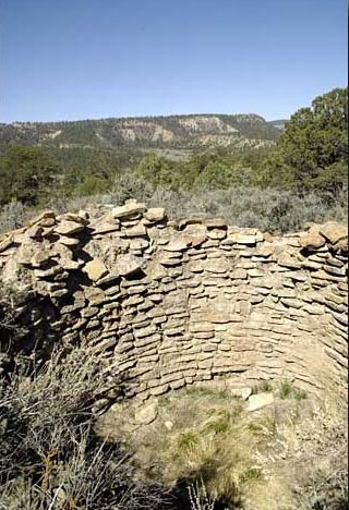
The trail moves up at a mild incline about a tenth of a mile to a T. At the T, going right takes you to the best ruins on the ridge and a very nice overlook. The first structure you come to was probably a tower, one of only three found in the area. Archeologists think the towers were used for storage rather than observation.
You are looking at structures that were probably built around 1,000 A.D. by a Pueblo Indian Group specific to this area called the Gallina (guy-ee-nah). They abandoned the area some time in the 1,200’s.
The Gallina were not a part of, and were isolated from, other, more advanced pueblo cultures like those at Mesa Verde and Chaco. Perhaps because of this isolation, they lasted longer.
What you don’t see in a brief visit here are signs of Gallina occupation for over a mile along this ridge.
Contributed by Bill Leverton.